Viewing the Data Displayed on the Map
The Advanced GIS tool is used to view the data referring to
definite territorial units – provinces and/or cities/villages
when zoomed in to this level. In order to access the data for
a specific territorial unit, point the mouse cursor on the ![]() button (Figure: Viewing the Data Displayed on the
Map). The information that is displayed in the information window
includes but is not limited to # of projects implemented in the
given administrative territory, # of contracts, # of requests,
etc. If you have plotted any chart category on the map, the chart
category details appear in the information window as well.
button (Figure: Viewing the Data Displayed on the
Map). The information that is displayed in the information window
includes but is not limited to # of projects implemented in the
given administrative territory, # of contracts, # of requests,
etc. If you have plotted any chart category on the map, the chart
category details appear in the information window as well.
Also, you can view information on nationwide projects and the
ones implemented in outside of Iraq. Moreover, you can also view
the synopsis of the projects that do not have any territorial
reference or are of various types. To view data on these projects,
point the mouse cursor on  button in the respective
section.
button in the respective
section.
Note: Clicking the View Projects link at the bottom of the information window will take you to the Details section of the application. For more information about the actions that can be taken in this section, see DETAILS SECTION.
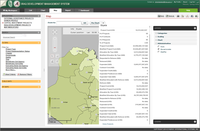 |
Figure: Viewing the Data Displayed on the Map |